Geolocate

Hampton topographic map

Click on the map to display elevation.

About this map

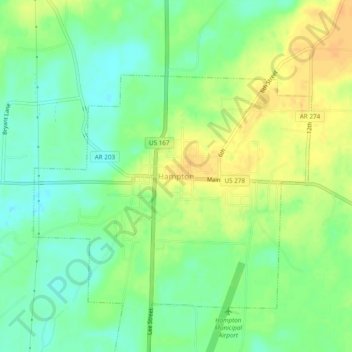
Name: Hampton topographic map, elevation, terrain.

Location: Hampton, Calhoun County, Arkansas, 71744, United States (33.51802 -92.48687 33.55802 -92.44687)

Average elevation: 177 ft

Minimum elevation: 128 ft

Maximum elevation: 230 ft

Calhoun County trails, hiking, mountain biking, running and outdoor activities

Gear up for your next adventure:

🦶Carbon Trekking Poles - Reduce knee impact on steep descents with ultra-light poles
Backpacking Tent - Lightweight and durable tent for multi‑day hikes
🪵Folding Camp Saw - Compact saw for wood and campsite work
🪄Magnetic Compass - Accurate compass for navigation
🔥Plasma Lighters - Windproof lighters that work in any weather condition

As an Amazon Associate, this site earns from qualifying purchases at no extra cost to you.