
Thank you for supporting this site ❤️
Make a donation
Make a donation
Gear up for your next adventure:
As an Amazon Associate, this site earns from qualifying purchases at no extra cost to you.
Bruceto topographic map
Click on the map to display elevation.
Thank you for supporting this site ❤️
Make a donation
Make a donation
Gear up for your next adventure:
As an Amazon Associate, this site earns from qualifying purchases at no extra cost to you.
About this map
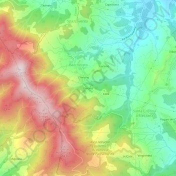
Name: Bruceto topographic map, elevation, terrain.
Location: Bruceto, Bacchereto, Carmignano, Prato, Toscana, Italia (43.78465 10.96779 43.82465 11.00779)
Average elevation: 984 ft
Minimum elevation: 167 ft
Maximum elevation: 2,070 ft
Thank you for supporting this site ❤️
Make a donation
Make a donation
Gear up for your next adventure:
As an Amazon Associate, this site earns from qualifying purchases at no extra cost to you.