
Cazin topographic map
Click on the map to display elevation.
About this map
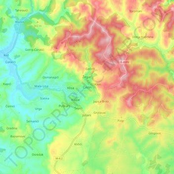
Name: Cazin topographic map, elevation, terrain.
Average elevation: 1,230 ft
Minimum elevation: 892 ft
Maximum elevation: 1,663 ft
Other topographic maps
Click on a map to view its topography, its elevation and its terrain.
Rujnica
Bosnia and Herzegovina > Federation of Bosnia and Herzegovina > City of Cazin > Rujnica
Average elevation: 994 ft
Pivnice
Bosnia and Herzegovina > Federation of Bosnia and Herzegovina > City of Cazin > Pivnice
Average elevation: 1,243 ft
Tržac
Bosnia and Herzegovina > Federation of Bosnia and Herzegovina > City of Cazin > Tržac
Average elevation: 922 ft