Geolocate

Lucas topographic map

Click on the map to display elevation.

About this map

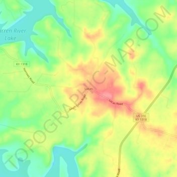
Name: Lucas topographic map, elevation, terrain.

Location: Lucas, Barren County, Kentucky, 42156, United States (36.87172 -86.05748 36.91172 -86.01748)

Average elevation: 646 ft

Minimum elevation: 509 ft

Maximum elevation: 797 ft

Barren County trails, hiking, mountain biking, running and outdoor activities

Other topographic maps

Click on a map to view its topography, its elevation and its terrain.

Park City

United States > Kentucky > Barren County

Average elevation: 659 ft

Glasgow

United States > Kentucky > Barren County

Average elevation: 755 ft

Cave City

United States > Kentucky > Barren County

Average elevation: 679 ft

Gear up for your next adventure:

📦Gear Storage Bags - Organize and protect outdoor equipment
❄️Traction Cleats - Prevent slips on icy trails during winter hikes
🧷Carabiner Set - Durable clips for gear attachment
🏕️Family Camping Gear - Essentials for group camping trips
🦺Reflective Outdoor Gear - Safety gear for low‑light conditions

As an Amazon Associate, this site earns from qualifying purchases at no extra cost to you.