
Make a donation
Gear up for your next adventure:
As an Amazon Associate, this site earns from qualifying purchases at no extra cost to you.
Sankt Martin topographic map
Click on the map to display elevation.
Make a donation
Gear up for your next adventure:
As an Amazon Associate, this site earns from qualifying purchases at no extra cost to you.
Sankt Martin
Sankt Martin lebt überwiegend vom Wein der auf etwa 200 Hektar in den beiden Einzellagen Baron und Kirchberg – beide Bestandteil der Großlage Schloß Ludwigshöhe – angebaut wird. Der Ort ist Teil des Weinanbaugebiet Pfalz. Damit verbundenen ist das Tourismusaufkommen ebenfalls ein bedeutender Wirtschaftsfaktor. Der landschaftsprägende Hausberg über dem Ort wurde 2012 querterrassiert und überwiegend neu mit Reben bestockt. Diese von weitem sichtbare Lage wird volkstümlich als „St. Martiner Wingertsberg“ bezeichnet.
Make a donation
Gear up for your next adventure:
As an Amazon Associate, this site earns from qualifying purchases at no extra cost to you.
About this map
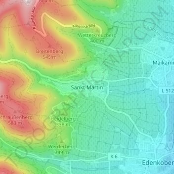
Name: Sankt Martin topographic map, elevation, terrain.
Average elevation: 1,010 ft
Minimum elevation: 495 ft
Maximum elevation: 2,201 ft
Make a donation
Gear up for your next adventure:
As an Amazon Associate, this site earns from qualifying purchases at no extra cost to you.