
Make a donation
Gear up for your next adventure:
As an Amazon Associate, this site earns from qualifying purchases at no extra cost to you.
Lindewitt topographic map
Click on the map to display elevation.
Make a donation
Gear up for your next adventure:
As an Amazon Associate, this site earns from qualifying purchases at no extra cost to you.
About this map
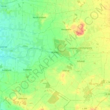
Name: Lindewitt topographic map, elevation, terrain.
Average elevation: 56 ft
Minimum elevation: 10 ft
Maximum elevation: 125 ft
Make a donation
Gear up for your next adventure:
As an Amazon Associate, this site earns from qualifying purchases at no extra cost to you.
Other topographic maps
Click on a map to view its topography, its elevation and its terrain.
Glücksburg (Ostsee)
Deutschland > Schleswig-Holstein > Kreis Schleswig-Flensburg > Glücksburg (Ostsee)
Average elevation: 56 ft
Steinberghaff
Deutschland > Schleswig-Holstein > Kreis Schleswig-Flensburg > Steinbergholz
Average elevation: 13 ft
Make a donation
Gear up for your next adventure:
As an Amazon Associate, this site earns from qualifying purchases at no extra cost to you.
Terkelstoft
Deutschland > Schleswig-Holstein > Kreis Schleswig-Flensburg > Streichmühle
Average elevation: 95 ft
Make a donation
Gear up for your next adventure:
As an Amazon Associate, this site earns from qualifying purchases at no extra cost to you.
Make a donation
Gear up for your next adventure:
As an Amazon Associate, this site earns from qualifying purchases at no extra cost to you.
Lüttfeld
Deutschland > Schleswig-Holstein > Kreis Schleswig-Flensburg > Kappeln
Average elevation: 39 ft
Make a donation
Gear up for your next adventure:
As an Amazon Associate, this site earns from qualifying purchases at no extra cost to you.
Schausende
Deutschland > Schleswig-Holstein > Kreis Schleswig-Flensburg > Glücksburg (Ostsee)
Average elevation: 10 ft
Sörupmühle
Deutschland > Schleswig-Holstein > Kreis Schleswig-Flensburg > Flatzby
Average elevation: 144 ft
Make a donation
Gear up for your next adventure:
As an Amazon Associate, this site earns from qualifying purchases at no extra cost to you.
Brarupholz
Deutschland > Schleswig-Holstein > Kreis Schleswig-Flensburg > Scheggerott
Average elevation: 138 ft
Ulsnisland
Deutschland > Schleswig-Holstein > Kreis Schleswig-Flensburg > Ulsnis
Average elevation: 43 ft
Alt Hasselberg
Deutschland > Schleswig-Holstein > Kreis Schleswig-Flensburg > Hasselberg
Average elevation: 10 ft
Tolkschuby
Deutschland > Schleswig-Holstein > Kreis Schleswig-Flensburg > Tolk
Average elevation: 75 ft
Make a donation
Gear up for your next adventure:
As an Amazon Associate, this site earns from qualifying purchases at no extra cost to you.
Rabenkirchen
Deutschland > Schleswig-Holstein > Kreis Schleswig-Flensburg > Rabenkirchen-Faulück
Average elevation: 102 ft
Ulegraff
Deutschland > Schleswig-Holstein > Kreis Schleswig-Flensburg > Brunsholm
Average elevation: 141 ft
Make a donation
Gear up for your next adventure:
As an Amazon Associate, this site earns from qualifying purchases at no extra cost to you.
Gammelbyholz
Deutschland > Schleswig-Holstein > Kreis Schleswig-Flensburg > Sörup
Average elevation: 125 ft
Altholzkrug
Deutschland > Schleswig-Holstein > Kreis Schleswig-Flensburg > Handewitt
Average elevation: 131 ft
Make a donation
Gear up for your next adventure:
As an Amazon Associate, this site earns from qualifying purchases at no extra cost to you.
Lüttfeld
Deutschland > Schleswig-Holstein > Kreis Schleswig-Flensburg > Kappeln
Average elevation: 39 ft
Make a donation
Gear up for your next adventure:
As an Amazon Associate, this site earns from qualifying purchases at no extra cost to you.
Unewattfeld
Deutschland > Schleswig-Holstein > Kreis Schleswig-Flensburg > Unewatt
Average elevation: 89 ft
Steinberggaard
Deutschland > Schleswig-Holstein > Kreis Schleswig-Flensburg > Steinberg
Average elevation: 49 ft
Rückeberg
Deutschland > Schleswig-Holstein > Kreis Schleswig-Flensburg > Kappeln
Average elevation: 39 ft
Make a donation
Gear up for your next adventure:
As an Amazon Associate, this site earns from qualifying purchases at no extra cost to you.
Uelsbyholz
Deutschland > Schleswig-Holstein > Kreis Schleswig-Flensburg > Uelsby
Average elevation: 144 ft
Schnarup
Deutschland > Schleswig-Holstein > Kreis Schleswig-Flensburg > Schnarup-Thumby
Average elevation: 102 ft
Make a donation
Gear up for your next adventure:
As an Amazon Associate, this site earns from qualifying purchases at no extra cost to you.