
Wangoi topographic map
Click on the map to display elevation.
About this map
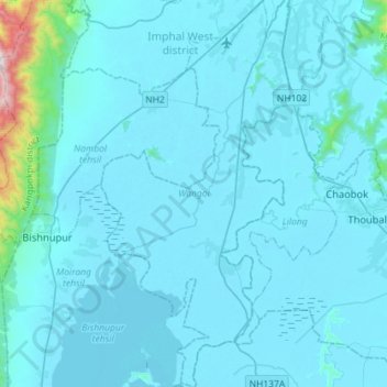
Name: Wangoi topographic map, elevation, terrain.
Location: Wangoi, Imphal West, Manipur, India (24.52569 93.79955 24.78572 93.94126)
Average elevation: 2,707 ft
Minimum elevation: 2,510 ft
Maximum elevation: 6,549 ft
Other topographic maps
Click on a map to view its topography, its elevation and its terrain.
Changangei Panchayat Tinpham Lampak
India > Manipur > Patsoi > Mayang Imphal
Average elevation: 2,549 ft