Geolocate

Dalton topographic map

Click on the map to display elevation.

About this map

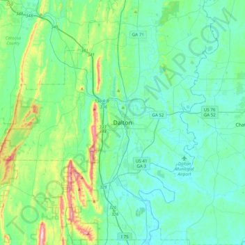
Name: Dalton topographic map, elevation, terrain.

Location: Dalton, Whitfield County, Georgia, 30720, United States (34.60919 -85.13025 34.92919 -84.81025)

Average elevation: 843 ft

Minimum elevation: 623 ft

Maximum elevation: 1,847 ft

Whitfield County trails, hiking, mountain biking, running and outdoor activities

Gear up for your next adventure:

🖼️Topo Map Wall Art - Decorative topographic prints of famous peaks and regions
😴Insulated Sleeping Pads - Compact and warm pads for high-elevation camping
🗃️Trail First Aid Kit - Essential kit for outdoor injuries and emergencies
🦶Hiking Gaiters - Keep debris and water out of your boots
🏫Relief Map Kits - Hands-on tools for teaching landforms and elevation

As an Amazon Associate, this site earns from qualifying purchases at no extra cost to you.