
Make a donation
Gear up for your next adventure:
As an Amazon Associate, this site earns from qualifying purchases at no extra cost to you.
Kohala Bala topographic map
Click on the map to display elevation.
Make a donation
Gear up for your next adventure:
As an Amazon Associate, this site earns from qualifying purchases at no extra cost to you.
About this map
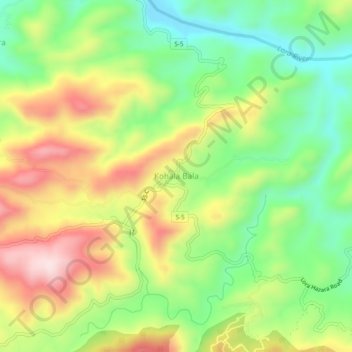
Name: Kohala Bala topographic map, elevation, terrain.
Average elevation: 3,271 ft
Minimum elevation: 2,703 ft
Maximum elevation: 4,003 ft
Make a donation
Gear up for your next adventure:
As an Amazon Associate, this site earns from qualifying purchases at no extra cost to you.
Other topographic maps
Click on a map to view its topography, its elevation and its terrain.
Tarbela Dam
Pakistan > Khyber Pakhtunkhwa > Haripur District
Tarbela Reservoir is 80.5 kilometres (50.0 mi) long, with a surface area of 250 square kilometres (97 sq mi). The reservoir initially stored 11,600,000 acre-feet (14.3 km3) of water, with a live storage of 9,700,000 acre-feet (12.0 km3), though this figure has been reduced over the subsequent 35 years of…
Average elevation: 1,480 ft