
Make a donation
Gear up for your next adventure:
As an Amazon Associate, this site earns from qualifying purchases at no extra cost to you.
Isla Patricio Lynch topographic map
Click on the map to display elevation.
Make a donation
Gear up for your next adventure:
As an Amazon Associate, this site earns from qualifying purchases at no extra cost to you.
About this map
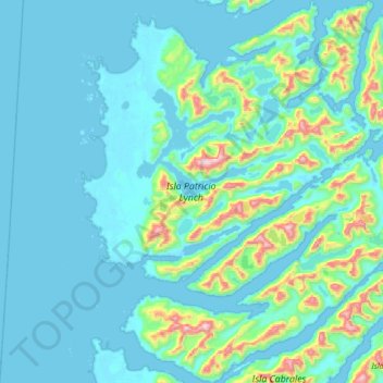
Name: Isla Patricio Lynch topographic map, elevation, terrain.
Average elevation: 344 ft
Minimum elevation: -13 ft
Maximum elevation: 2,657 ft
Make a donation
Gear up for your next adventure:
As an Amazon Associate, this site earns from qualifying purchases at no extra cost to you.
Other topographic maps
Click on a map to view its topography, its elevation and its terrain.
Clear water
Chile > Aysen del General Carlos Ibanez del Campo Region > Provincia de Capitán Prat > O’Higgins
Average elevation: 1,309 ft
Cerro Arco
Chile > Aysen del General Carlos Ibanez del Campo Region > Provincia de Capitán Prat > Cochrane
Average elevation: 8,058 ft