
Make a donation
Gear up for your next adventure:
As an Amazon Associate, this site earns from qualifying purchases at no extra cost to you.
Igensdorf topographic map
Click on the map to display elevation.
Make a donation
Gear up for your next adventure:
As an Amazon Associate, this site earns from qualifying purchases at no extra cost to you.
Igensdorf
St. Martin la Plaine liegt etwa 25 Kilometer südwestlich von Lyon und hat etwa 3500 Einwohner. Seine Fläche beträgt etwa 970 Hektar. Die durchschnittliche Höhe beträgt 430 Meter über dem Meeresspiegel. Die Gegend um St. Martin la Plaine ist geprägt von landwirtschaftlicher Nutzung, Obst- und Weinbau. Die Partnergemeinde hat eine lange Tradition im Schmiedehandwerk. Heute sind die meisten Werkstätten geschlossen, man betätigt sich nur noch mit Kunstschmiedearbeiten.
Make a donation
Gear up for your next adventure:
As an Amazon Associate, this site earns from qualifying purchases at no extra cost to you.
About this map
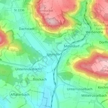
Name: Igensdorf topographic map, elevation, terrain.
Location: Igensdorf, Landkreis Forchheim, Bayern, 91338, Deutschland (49.60255 11.21173 49.64255 11.25173)
Average elevation: 1,270 ft
Minimum elevation: 1,043 ft
Maximum elevation: 1,726 ft
Make a donation
Gear up for your next adventure:
As an Amazon Associate, this site earns from qualifying purchases at no extra cost to you.