Geolocate

San Isidro topographic map

Click on the map to display elevation.

About this map

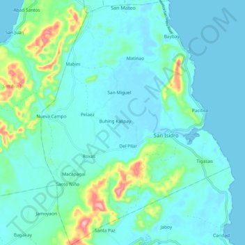
Name: San Isidro topographic map, elevation, terrain.

Location: San Isidro, Surigao del Norte, Caraga, 8421, Philippines (9.89146 126.03499 9.99171 126.11374)

Average elevation: 89 ft

Minimum elevation: 0 ft

Maximum elevation: 554 ft

Gear up for your next adventure:

🧥Waterproof Jacket for Hiking - Breathable and rugged rain jacket for outdoor excursions
🧷Carabiner Set - Durable clips for gear attachment
🧢Outdoor Hiking Hat - Sun protection hat for outdoor explorers
🌐World Map Poster - Decorative world maps with topographic info
🌧️Backpack Rain Cover - Keep gear dry in wet weather

As an Amazon Associate, this site earns from qualifying purchases at no extra cost to you.