Geolocate

Narela topographic map

Click on the map to display elevation.

About this map

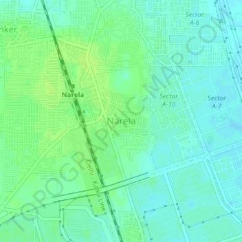
Name: Narela topographic map, elevation, terrain.

Location: Narela, Narela Tehsil, North Delhi, Delhi, 110040, India (28.83261 77.08184 28.85261 77.10184)

Average elevation: 712 ft

Minimum elevation: 692 ft

Maximum elevation: 728 ft

Other topographic maps

Click on a map to view its topography, its elevation and its terrain.

Tikri Khurd

India > Delhi > Narela Tehsil

Average elevation: 696 ft

Gear up for your next adventure:

🔥Fast-Boil Camping Stoves - Efficient cooking systems for quick trail meals
🧦Merino Wool Socks - Moisture-wicking, blister-preventing socks for long treks
🔦LED Headlamp - Bright and durable LED headlamp for night navigation
🧤Tactile Hiking Gloves - Keep hands warm while operating GPS and smartphone screens
🚗GPS Dash Cams - Record your scenic drives through mountain passes and canyons

As an Amazon Associate, this site earns from qualifying purchases at no extra cost to you.