Geolocate

Cougar topographic map

Click on the map to display elevation.

About this map

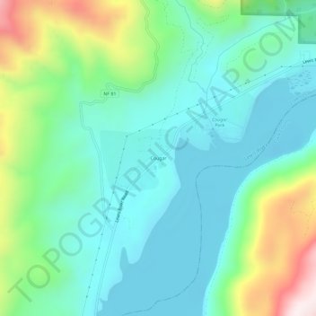
Name: Cougar topographic map, elevation, terrain.

Location: Cougar, Cowlitz County, Washington, 98616, United States (46.03126 -122.32242 46.07126 -122.28242)

Average elevation: 1,020 ft

Minimum elevation: 430 ft

Maximum elevation: 2,723 ft

Cowlitz County trails, hiking, mountain biking, running and outdoor activities

Other topographic maps

Click on a map to view its topography, its elevation and its terrain.

Pekin Ferry

United States > Washington > Cowlitz County

Average elevation: 135 ft

Gear up for your next adventure:

🌄Hiking Binoculars - Compact binoculars for scenic views and trail spotting
🧣Hiking Neck Gaiter - Multi‑use neck protection for outdoor weather
🏔️Mountain Trail Maps - High‑detail maps for popular peaks
🧦Hiking Socks - Comfortable socks to prevent blisters on long hikes
🧦Merino Wool Socks - Moisture-wicking, blister-preventing socks for long treks

As an Amazon Associate, this site earns from qualifying purchases at no extra cost to you.