Geolocate

Salve topographic map

Click on the map to display elevation.

About this map

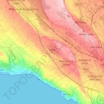
Name: Salve topographic map, elevation, terrain.

Location: Salve, Lecce, Apulia, Italy (39.83429 18.18667 39.88363 18.32651)

Average elevation: 315 ft

Minimum elevation: -7 ft

Maximum elevation: 607 ft

Gear up for your next adventure:

🛶Inflatable Kayak - Portable kayak for rivers, lakes, and expeditions
🧦Merino Wool Socks - Moisture-wicking, blister-preventing socks for long treks
🥩Freeze-Dried Meals - Nutritious and lightweight food for remote expeditions
🦟Ultrasonic Repellers - Create a bug-free zone at your camp or rest stop
🎒Day Hiking Backpack - Lightweight backpack perfect for day trips and outdoor adventures

As an Amazon Associate, this site earns from qualifying purchases at no extra cost to you.