
Make a donation
Gear up for your next adventure:
As an Amazon Associate, this site earns from qualifying purchases at no extra cost to you.
Hydra topographic map
Click on the map to display elevation.
Make a donation
Gear up for your next adventure:
As an Amazon Associate, this site earns from qualifying purchases at no extra cost to you.
About this map
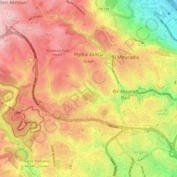
Name: Hydra topographic map, elevation, terrain.
Location: Hydra, Bir Mourad Rais District, Algiers, Algeria (36.72426 3.00151 36.75709 3.04928)
Average elevation: 528 ft
Minimum elevation: 3 ft
Maximum elevation: 853 ft
Make a donation
Gear up for your next adventure:
As an Amazon Associate, this site earns from qualifying purchases at no extra cost to you.
Other topographic maps
Click on a map to view its topography, its elevation and its terrain.
Oued El Kerma
Algeria > Algiers > Bir Mourad Rais District > Saoula > Swayah
Average elevation: 335 ft
Gué de Constantine
Algeria > Algiers > Bir Mourad Rais District > Gué de Constantine
Average elevation: 157 ft
Make a donation
Gear up for your next adventure:
As an Amazon Associate, this site earns from qualifying purchases at no extra cost to you.