
Make a donation
Gear up for your next adventure:
As an Amazon Associate, this site earns from qualifying purchases at no extra cost to you.
Ka-Ho Village topographic map
Click on the map to display elevation.
Make a donation
Gear up for your next adventure:
As an Amazon Associate, this site earns from qualifying purchases at no extra cost to you.
About this map
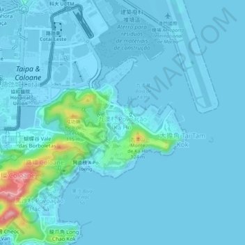
Name: Ka-Ho Village topographic map, elevation, terrain.
Location: Ka-Ho Village, Macau, 999078, China (22.11250 113.56136 22.15250 113.60136)
Average elevation: 43 ft
Minimum elevation: -16 ft
Maximum elevation: 505 ft
Make a donation
Gear up for your next adventure:
As an Amazon Associate, this site earns from qualifying purchases at no extra cost to you.
Other topographic maps
Click on a map to view its topography, its elevation and its terrain.
Taipa Central Park
China > Macau > 嘉模堂區 Nossa Senhora do Carmo > 花城 Cidade das Flores
Average elevation: 36 ft
Make a donation
Gear up for your next adventure:
As an Amazon Associate, this site earns from qualifying purchases at no extra cost to you.
Make a donation
Gear up for your next adventure:
As an Amazon Associate, this site earns from qualifying purchases at no extra cost to you.