
Make a donation
Gear up for your next adventure:
As an Amazon Associate, this site earns from qualifying purchases at no extra cost to you.
Paschenberg topographic map
Click on the map to display elevation.
Make a donation
Gear up for your next adventure:
As an Amazon Associate, this site earns from qualifying purchases at no extra cost to you.
About this map
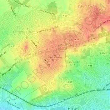
Name: Paschenberg topographic map, elevation, terrain.
Average elevation: 276 ft
Minimum elevation: 180 ft
Maximum elevation: 351 ft
Make a donation
Gear up for your next adventure:
As an Amazon Associate, this site earns from qualifying purchases at no extra cost to you.
Other topographic maps
Click on a map to view its topography, its elevation and its terrain.
Bertlich
Deutschland > Nordrhein-Westfalen > Kreis Recklinghausen > Herten > Westerholt
Average elevation: 230 ft
Scherlebeck
Deutschland > Nordrhein-Westfalen > Kreis Recklinghausen > Herten
Average elevation: 285 ft
45701
Deutschland > Nordrhein-Westfalen > Kreis Recklinghausen > Herten > Westerholt
Average elevation: 246 ft
Make a donation
Gear up for your next adventure:
As an Amazon Associate, this site earns from qualifying purchases at no extra cost to you.
Bertlich
Deutschland > Nordrhein-Westfalen > Kreis Recklinghausen > Herten > Westerholt
Average elevation: 230 ft