Geolocate

Taishitun topographic map

Click on the map to display elevation.

About this map

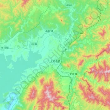
Name: Taishitun topographic map, elevation, terrain.

Location: Taishitun, Miyun District, Beijing, China (40.44773 116.98503 40.65018 117.30344)

Average elevation: 1,096 ft

Minimum elevation: 295 ft

Maximum elevation: 3,284 ft

Other topographic maps

Click on a map to view its topography, its elevation and its terrain.

Daling

China > Beijing > Miyun District

Average elevation: 2,031 ft

Gear up for your next adventure:

🦶Hiking Gaiters - Keep debris and water out of your boots
🗺️NatGeo Topo Maps - High-quality waterproof printed topographic maps of US Parks
🧤Hiking Gloves - Protective gloves for rugged trails
🩹Survival Bandages - High‑quality bandages for emergencies
⛑️Personal Locator Beacon - Safety beacon for emergencies

As an Amazon Associate, this site earns from qualifying purchases at no extra cost to you.