Geolocate

Rumford topographic map

Click on the map to display elevation.

About this map

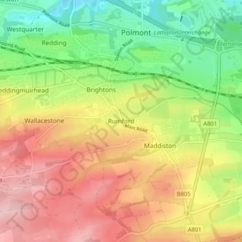
Name: Rumford topographic map, elevation, terrain.

Location: Rumford, Falkirk, Scotland, FK2 0SD, United Kingdom (55.95598 -3.73190 55.99598 -3.69190)

Average elevation: 341 ft

Minimum elevation: 33 ft

Maximum elevation: 659 ft

Gear up for your next adventure:

🔭Compact Binoculars - HD vision for scouting terrain and identifying distant landmarks
🧥Men's Rain Shells - Premium waterproof and breathable jackets for mountain weather
📖Nature Tracking Books - Learn to track wildlife and terrain
🧣Merino Neck Gaiters - Multi-functional headwear for wind and sun protection
🥄Camping Utensil Set - Lightweight utensils for outdoor meals

As an Amazon Associate, this site earns from qualifying purchases at no extra cost to you.