Geolocate
Thank you for supporting this site ❤️Make a donation

Hart Island topographic map

Click on the map to display elevation.

About this map

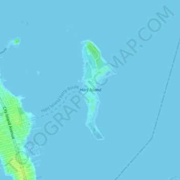
Name: Hart Island topographic map, elevation, terrain.

Location: Hart Island, New York, United States (40.84511 -73.77246 40.86002 -73.76533)

Average elevation: 3 ft

Minimum elevation: -3 ft

Maximum elevation: 39 ft

Other topographic maps

Click on a map to view its topography, its elevation and its terrain.

Manhattan Island

United States > New York > New York

Manhattan Island, New York, United States

Average elevation: 56 ft

Queens

United States > New York > New York

Queens, New York, United States

Average elevation: 36 ft

Upper West Side

United States > New York > New York

Upper West Side, Manhattan Community Board 7, Manhattan, New York County, New York, United States

Average elevation: 75 ft

The Bronx

United States > New York > New York

The Bronx, New York, United States

Average elevation: 75 ft

Brooklyn

United States > New York > New York

Brooklyn, Kings County, New York, United States

Average elevation: 30 ft

Staten Island

United States > New York > New York

Staten Island, New York, United States

Average elevation: 30 ft

New York County

United States > New York > New York

New York County, New York, United States

Average elevation: 52 ft

Coney Island Creek Park

United States > New York > New York

Coney Island Creek Park, Coney Island, Kings County, New York, United States

Average elevation: 7 ft

Washington Heights

United States > New York > New York

Washington Heights, Manhattan Community Board 12, Manhattan, New York County, New York, United States

Average elevation: 82 ft

Jerome Park Reservoir

United States > New York > New York

Jerome Park Reservoir, The Bronx, New York, United States

Average elevation: 115 ft

Queens County

United States > New York > New York

Queens County, New York, United States

Average elevation: 36 ft

Flushing Meadows-Corona Park

United States > New York > New York

Flushing Meadows-Corona Park, New York, United States

Average elevation: 49 ft

Fort Greene Park

United States > New York > New York

Fort Greene Park, Fort Greene, Kings County, New York, United States

Average elevation: 56 ft

McCarren Park

United States > New York > New York

McCarren Park, Kings County, New York, United States

Average elevation: 23 ft

Highland Park

United States > New York > New York

Highland Park, Queens County, New York, United States

Average elevation: 92 ft

Bronx County

United States > New York > New York

Bronx County, The Bronx, New York, United States

Average elevation: 69 ft

In order to remain free and to keep improving, this site uses cookies created by Google to compile visit statistics and display personalized advertisements.

How is the collected data used?