
Make a donation
Gear up for your next adventure:
As an Amazon Associate, this site earns from qualifying purchases at no extra cost to you.
Riebeek East topographic map
Click on the map to display elevation.
Make a donation
Gear up for your next adventure:
As an Amazon Associate, this site earns from qualifying purchases at no extra cost to you.
About this map
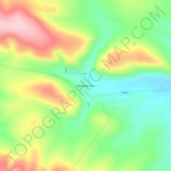
Name: Riebeek East topographic map, elevation, terrain.
Average elevation: 2,339 ft
Minimum elevation: 2,031 ft
Maximum elevation: 2,749 ft
Make a donation
Gear up for your next adventure:
As an Amazon Associate, this site earns from qualifying purchases at no extra cost to you.
Other topographic maps
Click on a map to view its topography, its elevation and its terrain.
Buffalo Kloof Protected Environment
South Africa > Eastern Cape > Sarah Baartman District Municipality > Makana Local Municipality
Average elevation: 932 ft
Glen Melville Dam
South Africa > Eastern Cape > Sarah Baartman District Municipality > Makana Local Municipality
Average elevation: 938 ft
Makana Ward 14
South Africa > Eastern Cape > Sarah Baartman District Municipality > Makana Local Municipality
Average elevation: 1,411 ft