
Make a donation
Gear up for your next adventure:
As an Amazon Associate, this site earns from qualifying purchases at no extra cost to you.
Talmine topographic map
Click on the map to display elevation.
Make a donation
Gear up for your next adventure:
As an Amazon Associate, this site earns from qualifying purchases at no extra cost to you.
Talmine
Talmine commune lies at an elevation of about 364 metres (1,194 ft). It covers the westernmost oases in the Gourara region of northern Adrar Province (excepting the villages of Meslila and Bent Cherk that lies in Béchar Province. The oases mainly lie in the southernmost part of the Grand Erg Occidental, a large area of sand dunes stretching well into Béchar and El Bayadh provinces.
Make a donation
Gear up for your next adventure:
As an Amazon Associate, this site earns from qualifying purchases at no extra cost to you.
About this map
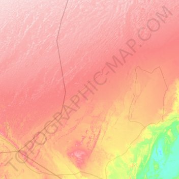
Name: Talmine topographic map, elevation, terrain.
Location: Talmine, Charouine District, Timimoune, Algeria (28.83645 -0.92035 29.75797 -0.31984)
Average elevation: 1,175 ft
Minimum elevation: 558 ft
Maximum elevation: 1,611 ft
Make a donation
Gear up for your next adventure:
As an Amazon Associate, this site earns from qualifying purchases at no extra cost to you.