
Serre topographic map
Interactive map
Click on the map to display elevation.
About this map
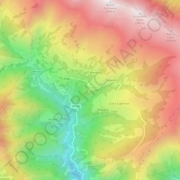
Name: Serre topographic map, elevation, terrain.
Location: Serre, Elva, Coni, Piémont, Italie (44.51994 7.06998 44.55994 7.10998)
Average elevation: 5,928 ft
Minimum elevation: 3,816 ft
Maximum elevation: 7,822 ft
Other topographic maps
Click on a map to view its topography, its elevation and its terrain.
Chiosso Superiore
Italie > Piémont > Coni > Elva
Chiosso Superiore, Elva, Coni, Piémont, Italie
Average elevation: 6,375 ft
Colle di Sampeyre
Italie > Piémont > Coni > Elva
Colle di Sampeyre, Strada Sampeyre - Colle Sampeyre, Elva, Coni, Piémont, Italie
Average elevation: 6,811 ft