
Make a donation
Gear up for your next adventure:
As an Amazon Associate, this site earns from qualifying purchases at no extra cost to you.
Lac Lili topographic map
Click on the map to display elevation.
Make a donation
Gear up for your next adventure:
As an Amazon Associate, this site earns from qualifying purchases at no extra cost to you.
About this map
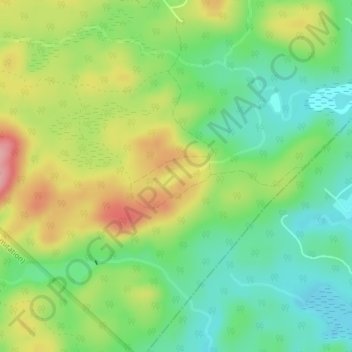
Name: Lac Lili topographic map, elevation, terrain.
Location: Lac Lili, Chertsey, Matawinie, Lanaudière, Québec, Canada (46.00661 -73.95316 46.00834 -73.94796)
Average elevation: 1,158 ft
Minimum elevation: 994 ft
Maximum elevation: 1,401 ft
Make a donation
Gear up for your next adventure:
As an Amazon Associate, this site earns from qualifying purchases at no extra cost to you.
Other topographic maps
Click on a map to view its topography, its elevation and its terrain.
Lac Beaulac
Canada > Québec > Matawinie > Chertsey > Notre-Dame-de-Beaulac
Average elevation: 1,112 ft
Make a donation
Gear up for your next adventure:
As an Amazon Associate, this site earns from qualifying purchases at no extra cost to you.
Make a donation
Gear up for your next adventure:
As an Amazon Associate, this site earns from qualifying purchases at no extra cost to you.