Geolocate

Prairie View topographic map

Click on the map to display elevation.

About this map

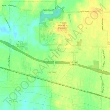
Name: Prairie View topographic map, elevation, terrain.

Location: Prairie View, Waller County, Texas, 77446, United States (30.06105 -96.01378 30.10622 -95.96044)

Average elevation: 259 ft

Minimum elevation: 210 ft

Maximum elevation: 295 ft

Waller County trails, hiking, mountain biking, running and outdoor activities

Other topographic maps

Click on a map to view its topography, its elevation and its terrain.

Monaville

United States > Texas > Waller County

Average elevation: 177 ft

Monaville

United States > Texas > Waller County

Average elevation: 177 ft

Gear up for your next adventure:

Backpacking Tent - Lightweight and durable tent for multi‑day hikes
🖼️Topo Map Wall Art - Decorative topographic prints of famous peaks and regions
💧Water Filtration Bottles - Safely drink from streams and lakes while exploring
🔦LED Headlamp - Bright and durable LED headlamp for night navigation
🔭Stargazing Telescopes - Perfect for camping in low-light pollution areas shown on maps

As an Amazon Associate, this site earns from qualifying purchases at no extra cost to you.