Geolocate

dharni topographic map

Click on the map to display elevation.

About this map

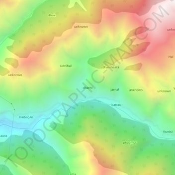
Name: dharni topographic map, elevation, terrain.

Location: dharni, Banihal, Ramban District, Jammu and Kashmir, India (33.31762 75.21439 33.35762 75.25439)

Average elevation: 6,037 ft

Minimum elevation: 3,921 ft

Maximum elevation: 8,819 ft

Gear up for your next adventure:

👟Trail Running Shoes - Lightweight shoes for trail runners
🪶Thermal Camp Blanket - Extra warmth for cold nights
🔭Telescopic Hiking Pole - Adjustable pole for hiking stability
👟Men's Trail Runners - Lightweight footwear for fast-paced exploration and light hiking
📌Outdoor GPS Map App - Apps and devices for digital topographic navigation

As an Amazon Associate, this site earns from qualifying purchases at no extra cost to you.