Geolocate

Brooklin topographic map

Click on the map to display elevation.

About this map

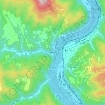
Name: Brooklin topographic map, elevation, terrain.

Location: Brooklin, Summers County, West Virginia, 25951, United States (37.65317 -80.91731 37.69317 -80.87731)

Average elevation: 1,785 ft

Minimum elevation: 1,322 ft

Maximum elevation: 2,867 ft

Other topographic maps

Click on a map to view its topography, its elevation and its terrain.

Hinton

United States > West Virginia > Summers County

Average elevation: 2,028 ft

Bluestone National Scenic River

United States > West Virginia > Summers County

The headwaters of the Bluestone River begin at an elevation of 3500 feet on East River Mountain near Bluefield, Virginia and flow for 77 miles to Bluestone Lake near Hinton, West Virginia at 1409 feet.

Average elevation: 2,287 ft

Gear up for your next adventure:

GPS Sports Watch - GPS watch for running, hiking and training
🦶Carbon Trekking Poles - Reduce knee impact on steep descents with ultra-light poles
🧭Compass with Lanyard - Easy‑carry compass for navigation
📱Solar Portable Charger - Solar power bank for charging devices off‑grid
🩳Quick‑Dry Hiking Shorts - Comfortable and quick‑dry shorts for summer hiking

As an Amazon Associate, this site earns from qualifying purchases at no extra cost to you.