
Thank you for supporting this site ❤️
Make a donation
Make a donation
Gear up for your next adventure:
As an Amazon Associate, this site earns from qualifying purchases at no extra cost to you.
Chiusola topographic map
Click on the map to display elevation.
Thank you for supporting this site ❤️
Make a donation
Make a donation
Gear up for your next adventure:
As an Amazon Associate, this site earns from qualifying purchases at no extra cost to you.
About this map
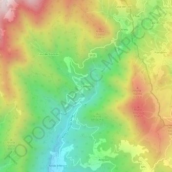
Name: Chiusola topographic map, elevation, terrain.
Location: Chiusola, Sesta Godano, La Spezia, Liguria, Italia (44.31744 9.68320 44.35744 9.72320)
Average elevation: 2,654 ft
Minimum elevation: 1,148 ft
Maximum elevation: 4,560 ft
Thank you for supporting this site ❤️
Make a donation
Make a donation
Gear up for your next adventure:
As an Amazon Associate, this site earns from qualifying purchases at no extra cost to you.