
Clyde topographic map
Click on the map to display elevation.
About this map
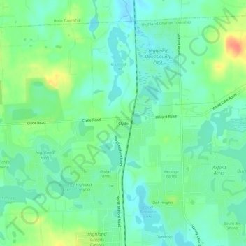
Name: Clyde topographic map, elevation, terrain.
Average elevation: 1,033 ft
Minimum elevation: 981 ft
Maximum elevation: 1,142 ft
Oakland County trails, hiking, mountain biking, running and outdoor activities
Other topographic maps
Click on a map to view its topography, its elevation and its terrain.
Duck Lake
United States > Michigan > Oakland County > Highland Charter Township > Seven Harbors
Average elevation: 1,027 ft