Geolocate

Login topographic map

Click on the map to display elevation.

About this map

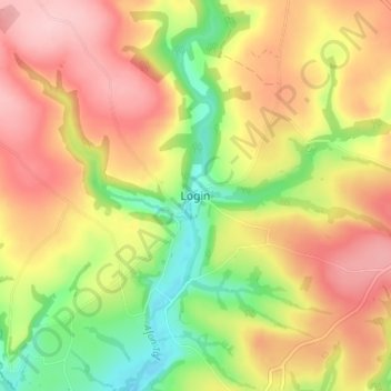
Name: Login topographic map, elevation, terrain.

Location: Login, Carmarthenshire, Wales, SA34 0XB, United Kingdom (51.86001 -4.68576 51.90001 -4.64576)

Average elevation: 417 ft

Minimum elevation: 118 ft

Maximum elevation: 673 ft

Gear up for your next adventure:

📡Handheld GPS Device - Reliable handheld GPS for outdoor navigation
🔌Solar Panel Charger - Charge gear sustainably outdoors
😴Insulated Sleeping Pads - Compact and warm pads for high-elevation camping
🛶Inflatable Kayak - Portable kayak for rivers, lakes, and expeditions
🧼Biodegradable Camping Soap - Eco‑friendly soap for outdoor hygiene

As an Amazon Associate, this site earns from qualifying purchases at no extra cost to you.