Geolocate

Saint Michaels topographic map

Click on the map to display elevation.

About this map
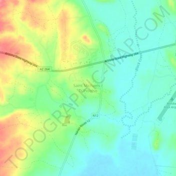
Name: Saint Michaels topographic map, elevation, terrain.

Location: Saint Michaels, Fort Defiance Agency, Apache County, Arizona, 86511, United States (35.63124 -109.11373 35.67124 -109.07373)

Average elevation: 6,755 ft

Minimum elevation: 6,663 ft

Maximum elevation: 6,926 ft

Apache County trails, hiking, mountain biking, running and outdoor activities

Other topographic maps

Click on a map to view its topography, its elevation and its terrain.
Chinle

United States > Arizona > Apache County

Average elevation: 5,627 ft

Chinle Agency

United States > Arizona > Apache County

Average elevation: 6,450 ft

Teec Nos Pos

United States > Arizona > Apache County

Average elevation: 5,315 ft

Round Rock

United States > Arizona > Apache County

Average elevation: 5,459 ft

Houck

United States > Arizona > Apache County

Average elevation: 6,201 ft

Burnside

United States > Arizona > Apache County

Average elevation: 6,447 ft

Bear Wallow Tank

United States > Arizona > Apache County

Average elevation: 8,176 ft

Pacheta Lake

United States > Arizona > Apache County

Average elevation: 8,301 ft

Lyman Lake

United States > Arizona > Apache County

Average elevation: 6,115 ft

St. Johns

United States > Arizona > Apache County

Average elevation: 5,764 ft

Window Rock

United States > Arizona > Apache County

Window Rock is categorized as being within the 6a USDA hardiness zone, meaning the average annual extreme minimum temperature is between −10 and −5 °F (−23 and −21 °C). The city is cooler than most of Arizona due to its high elevation.

Average elevation: 6,837 ft

Fort Defiance Agency

United States > Arizona > Apache County

Average elevation: 6,276 ft

St. Michaels

United States > Arizona > Apache County

Average elevation: 6,778 ft

Gear up for your next adventure:

🧥Waterproof Jacket for Hiking - Breathable and rugged rain jacket for outdoor excursions
🛠️Outdoor Gear Repair Kit - Essential tools to fix gear on the trail
🦶Carbon Trekking Poles - Reduce knee impact on steep descents with ultra-light poles
📌Outdoor GPS Map App - Apps and devices for digital topographic navigation
🪶Camping Sleeping Pad - Comfortable sleeping pad for backpacking

As an Amazon Associate, this site earns from qualifying purchases at no extra cost to you.