
Thank you for supporting this site ❤️
Make a donation
Make a donation
Gear up for your next adventure:
As an Amazon Associate, this site earns from qualifying purchases at no extra cost to you.
Zambrana topographic map
Click on the map to display elevation.
Thank you for supporting this site ❤️
Make a donation
Make a donation
Gear up for your next adventure:
As an Amazon Associate, this site earns from qualifying purchases at no extra cost to you.
About this map
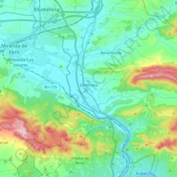
Name: Zambrana topographic map, elevation, terrain.
Location: Zambrana, Cuadrilla de Añana, Álava, País Vasco, España (42.63152 -2.90012 42.68566 -2.73760)
Average elevation: 1,831 ft
Minimum elevation: 1,447 ft
Maximum elevation: 3,114 ft
Thank you for supporting this site ❤️
Make a donation
Make a donation
Gear up for your next adventure:
As an Amazon Associate, this site earns from qualifying purchases at no extra cost to you.