
Ware topographic map
Click on the map to display elevation.
About this map
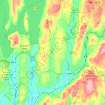
Name: Ware topographic map, elevation, terrain.
Location: Ware, Hampshire County, Massachusetts, 01082, United States (42.22016 -72.35602 42.35211 -72.20328)
Average elevation: 650 ft
Minimum elevation: 354 ft
Maximum elevation: 1,184 ft
Hampshire County trails, hiking, mountain biking, running and outdoor activities
Other topographic maps
Click on a map to view its topography, its elevation and its terrain.
South Hadley Falls
United States > Massachusetts > Hampshire County > South Hadley
Average elevation: 164 ft
Mill River Recreation Area
United States > Massachusetts > Hampshire County > Amherst > North Amherst
Average elevation: 217 ft
Wildwood Conservation Area
United States > Massachusetts > Hampshire County > Amherst
Average elevation: 292 ft
Worthington Corners
United States > Massachusetts > Hampshire County > Worthington
Average elevation: 1,476 ft