
Thank you for supporting this site ❤️
Make a donation
Make a donation
Gear up for your next adventure:
As an Amazon Associate, this site earns from qualifying purchases at no extra cost to you.
Boghni topographic map
Click on the map to display elevation.
Thank you for supporting this site ❤️
Make a donation
Make a donation
Gear up for your next adventure:
As an Amazon Associate, this site earns from qualifying purchases at no extra cost to you.
About this map
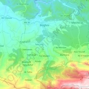
Name: Boghni topographic map, elevation, terrain.
Location: Boghni, Boghni District, Tizi Ouzou, 15003, Algeria (36.45643 3.92416 36.57371 4.01946)
Average elevation: 2,110 ft
Minimum elevation: 591 ft
Maximum elevation: 6,841 ft
Thank you for supporting this site ❤️
Make a donation
Make a donation
Gear up for your next adventure:
As an Amazon Associate, this site earns from qualifying purchases at no extra cost to you.