Geolocate

Puro Islet topographic map

Click on the map to display elevation.

About this map

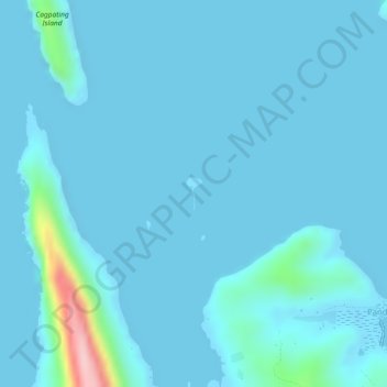
Name: Puro Islet topographic map, elevation, terrain.

Location: Puro Islet, Pandan, Masbate, Bicol Region, Philippines (12.64577 123.59309 12.64809 123.59422)

Average elevation: 49 ft

Minimum elevation: -16 ft

Maximum elevation: 659 ft

Gear up for your next adventure:

📶Vehicle Signal Boosters - Improve reception in rural areas while driving to trailheads
🎒Trail Energy Bars - High‑calorie bars for hiking energy
🪑Portable Camp Table - Compact table for campsite meals
🔌USB Car Charger - Car charger for on‑the‑go power needs
📻Weather Alert Radios - Stay informed of storm risks while off-the-grid

As an Amazon Associate, this site earns from qualifying purchases at no extra cost to you.