Geolocate

Coin topographic map

Click on the map to display elevation.

About this map

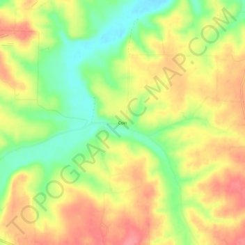
Name: Coin topographic map, elevation, terrain.

Location: Coin, Carroll County, Arkansas, United States (36.31035 -93.36796 36.35035 -93.32796)

Average elevation: 1,207 ft

Minimum elevation: 1,060 ft

Maximum elevation: 1,335 ft

Carroll County trails, hiking, mountain biking, running and outdoor activities

Gear up for your next adventure:

🥾Women's Hiking Boots - Top-rated trail boots with ankle support and superior grip
🔋Solar Power Banks - Keep your GPS and phone charged in remote wilderness areas
👖Convertible Hiking Pants - Versatile zip-off pants for changing altitudes and temperatures
👟Men's Trail Runners - Lightweight footwear for fast-paced exploration and light hiking
🗃️Trail First Aid Kit - Essential kit for outdoor injuries and emergencies

As an Amazon Associate, this site earns from qualifying purchases at no extra cost to you.