
Make a donation
Gear up for your next adventure:
As an Amazon Associate, this site earns from qualifying purchases at no extra cost to you.
Casbah topographic map
Click on the map to display elevation.
Make a donation
Gear up for your next adventure:
As an Amazon Associate, this site earns from qualifying purchases at no extra cost to you.
About this map
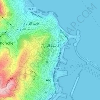
Name: Casbah topographic map, elevation, terrain.
Location: Casbah, Bab El Oued District, Algiers, Algeria (36.77678 3.04908 36.79051 3.07836)
Average elevation: 171 ft
Minimum elevation: -10 ft
Maximum elevation: 778 ft
Make a donation
Gear up for your next adventure:
As an Amazon Associate, this site earns from qualifying purchases at no extra cost to you.
Other topographic maps
Click on a map to view its topography, its elevation and its terrain.
Notre Dame d'Afrique
Algeria > Algiers > Bab El Oued District > Beau Fraisier
Average elevation: 279 ft
Droudj el Rounda (Rounda Steps)
Algeria > Algiers > Bab El Oued District > Beau Fraisier
Average elevation: 299 ft
Make a donation
Gear up for your next adventure:
As an Amazon Associate, this site earns from qualifying purchases at no extra cost to you.