
Tewkesbury topographic map
Interactive map
Click on the map to display elevation.
About this map
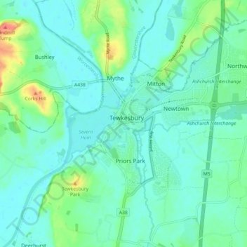
Name: Tewkesbury topographic map, elevation, terrain.
Average elevation: 59 ft
Minimum elevation: 20 ft
Maximum elevation: 200 ft
Other topographic maps
Click on a map to view its topography, its elevation and its terrain.
Bishop's Cleeve
United Kingdom > England > Gloucestershire > Tewkesbury > Gotherington
Bishop's Cleeve, Gotherington, Tewkesbury, Gloucestershire, England, United Kingdom
Average elevation: 167 ft
Crane Hill
United Kingdom > England > Gloucestershire > Tewkesbury
Crane Hill, Tewkesbury, Gloucestershire, England, GL52 9RG, United Kingdom
Average elevation: 253 ft
Snowshill
United Kingdom > England > Gloucestershire > Tewkesbury
Snowshill, Tewkesbury, Gloucestershire, England, WR12 7JX, United Kingdom
Average elevation: 807 ft