Geolocate

Decaturville topographic map

Click on the map to display elevation.

About this map

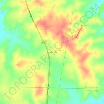
Name: Decaturville topographic map, elevation, terrain.

Location: Decaturville, Camden County, Missouri, 65537, United States (37.88754 -92.71990 37.92754 -92.67990)

Average elevation: 1,040 ft

Minimum elevation: 906 ft

Maximum elevation: 1,165 ft

Gear up for your next adventure:

📖Nature Tracking Books - Learn to track wildlife and terrain
🌡️Portable Weather Meter - Track weather conditions on the trail
🔊Portable Camp Speaker - Music and alerts at camp
🌐World Map Poster - Decorative world maps with topographic info
🧢Outdoor Hiking Hat - Sun protection hat for outdoor explorers

As an Amazon Associate, this site earns from qualifying purchases at no extra cost to you.