
Make a donation
Gear up for your next adventure:
As an Amazon Associate, this site earns from qualifying purchases at no extra cost to you.
Pleiku topographic map
Click on the map to display elevation.
Make a donation
Gear up for your next adventure:
As an Amazon Associate, this site earns from qualifying purchases at no extra cost to you.
Pleiku
Pleiku is located at an average altitude of 700m - 800m; Ham Rong junction, or the junction of National Highway 14 and National Highway 19 south of Pleiku, has an altitude of 785m.
Make a donation
Gear up for your next adventure:
As an Amazon Associate, this site earns from qualifying purchases at no extra cost to you.
About this map
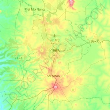
Name: Pleiku topographic map, elevation, terrain.
Location: Pleiku, Phường Hội Phú, Gia Lai Province, Vietnam (13.83408 107.83873 14.08711 108.09893)
Average elevation: 2,379 ft
Minimum elevation: 1,900 ft
Maximum elevation: 3,337 ft
Make a donation
Gear up for your next adventure:
As an Amazon Associate, this site earns from qualifying purchases at no extra cost to you.