
Make a donation
Gear up for your next adventure:
As an Amazon Associate, this site earns from qualifying purchases at no extra cost to you.
Loyalton topographic map
Click on the map to display elevation.
Make a donation
Gear up for your next adventure:
As an Amazon Associate, this site earns from qualifying purchases at no extra cost to you.
Loyalton
Loyalton is located at 39°40′36″N 120°14′35″W / 39.67667°N 120.24306°W / 39.67667; -120.24306 (39.676558, -120.243157). Elevation above mean sea level for the area was listed as roughly 4,930 feet (1,500 m). The city is located along California State Route 49, the Gold Country Highway.
Make a donation
Gear up for your next adventure:
As an Amazon Associate, this site earns from qualifying purchases at no extra cost to you.
About this map
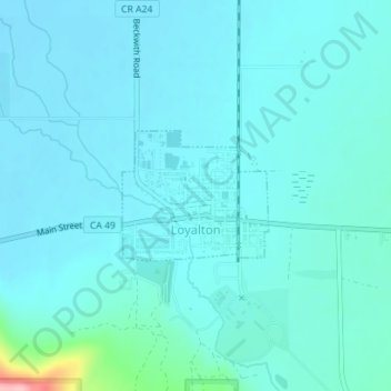
Name: Loyalton topographic map, elevation, terrain.
Location: Loyalton, Sierra County, California, 96118, United States (39.67292 -120.25096 39.68191 -120.23780)
Average elevation: 4,967 ft
Minimum elevation: 4,911 ft
Maximum elevation: 5,410 ft
Sierra County trails, hiking, mountain biking, running and outdoor activities
Make a donation
Gear up for your next adventure:
As an Amazon Associate, this site earns from qualifying purchases at no extra cost to you.
Other topographic maps
Click on a map to view its topography, its elevation and its terrain.
Sierra City
United States > California > Sierra County
Sierra City (Sierra, Spanish for "mountain range") is a census-designated place in Sierra County, California, United States. The elevation of Sierra City is 4,147 feet (1,264 m), and the town is situated in the canyon of the North Yuba River on California State Route 49, twelve miles northeast of the county…
Average elevation: 5,276 ft
Downieville
United States > California > Sierra County
Downieville is a census-designated place in and the county seat of Sierra County, California, United States. Downieville is on the North Fork of the Yuba River, at an elevation of 2,966 feet (904 m). The 2020 United States census reported Downieville's population was 290.
Average elevation: 3,796 ft
Make a donation
Gear up for your next adventure:
As an Amazon Associate, this site earns from qualifying purchases at no extra cost to you.
Sierra City
United States > California > Sierra County
Sierra City (Sierra, Spanish for "mountain range") is a census-designated place in Sierra County, California, United States. The elevation of Sierra City is 4,147 feet (1,264 m), and the town is situated in the canyon of the North Yuba River on California State Route 49, twelve miles northeast of the county…
Average elevation: 5,276 ft
Make a donation
Gear up for your next adventure:
As an Amazon Associate, this site earns from qualifying purchases at no extra cost to you.