
Make a donation
Gear up for your next adventure:
As an Amazon Associate, this site earns from qualifying purchases at no extra cost to you.
Gorak Shep topographic map
Click on the map to display elevation.
Make a donation
Gear up for your next adventure:
As an Amazon Associate, this site earns from qualifying purchases at no extra cost to you.
Gorak Shep
Gorak Shep or Gorakshep (Nepali: गोरकशेप) is a small settlement that sits on the edge of a frozen lakebed covered with sand in Nepal with the same name. It is found at an elevation of 5,164 metres (16,942 ft) elevation, near Mount Everest. The village is not inhabited year-round.
Make a donation
Gear up for your next adventure:
As an Amazon Associate, this site earns from qualifying purchases at no extra cost to you.
About this map
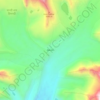
Name: Gorak Shep topographic map, elevation, terrain.
Average elevation: 17,241 ft
Minimum elevation: 16,253 ft
Maximum elevation: 19,262 ft
Make a donation
Gear up for your next adventure:
As an Amazon Associate, this site earns from qualifying purchases at no extra cost to you.
Other topographic maps
Click on a map to view its topography, its elevation and its terrain.
Make a donation
Gear up for your next adventure:
As an Amazon Associate, this site earns from qualifying purchases at no extra cost to you.