Geolocate

Progreso topographic map

Click on the map to display elevation.

About this map

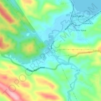
Name: Progreso topographic map, elevation, terrain.

Location: Progreso, Gumaca, Quezon, Calabarzon, 4307, Philippines (13.88844 122.06810 13.92844 122.10810)

Average elevation: 180 ft

Minimum elevation: 0 ft

Maximum elevation: 554 ft

Other topographic maps

Click on a map to view its topography, its elevation and its terrain.

Bagong Buhay

Philippines > Quezon > Gumaca > Progreso

Average elevation: 98 ft

Gear up for your next adventure:

🩹Survival Bandages - High‑quality bandages for emergencies
📚Navigation Handbooks - Master the art of reading topographic maps and using a compass
🧤Hiking Gloves - Protective gloves for rugged trails
🧣Merino Neck Gaiters - Multi-functional headwear for wind and sun protection
📶Vehicle Signal Boosters - Improve reception in rural areas while driving to trailheads

As an Amazon Associate, this site earns from qualifying purchases at no extra cost to you.