
Make a donation
Gear up for your next adventure:
As an Amazon Associate, this site earns from qualifying purchases at no extra cost to you.
Veracruz topographic map
Click on the map to display elevation.
Make a donation
Gear up for your next adventure:
As an Amazon Associate, this site earns from qualifying purchases at no extra cost to you.
Veracruz
Situado en la zona central del Estado en la costa del Golfo de México, su suelo es de pequeñas alturas insignificantes y de valles, con una altitud promedio de 10 m s. n. m., contando con buenas playas e islas, como las de Sacrificios, Verde, de Pájaros, Las Blanquillas, y la Gallega; en donde durante el Virreinato de la Nueva España fue construido el fuerte de San Juan de Ulúa.
Make a donation
Gear up for your next adventure:
As an Amazon Associate, this site earns from qualifying purchases at no extra cost to you.
About this map
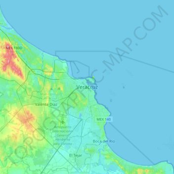
Name: Veracruz topographic map, elevation, terrain.
Location: Veracruz, Municipio de Veracruz, Veracruz, 91757, México (19.04034 -96.29836 19.36034 -95.97836)
Average elevation: 33 ft
Minimum elevation: -7 ft
Maximum elevation: 381 ft
Make a donation
Gear up for your next adventure:
As an Amazon Associate, this site earns from qualifying purchases at no extra cost to you.
Other topographic maps
Click on a map to view its topography, its elevation and its terrain.
Parque Fraccionamiento el faro
México > Veracruz > Municipio de Veracruz > Veracruz
Average elevation: 36 ft
Make a donation
Gear up for your next adventure:
As an Amazon Associate, this site earns from qualifying purchases at no extra cost to you.