
Make a donation
Gear up for your next adventure:
As an Amazon Associate, this site earns from qualifying purchases at no extra cost to you.
Dorchheim topographic map
Click on the map to display elevation.
Make a donation
Gear up for your next adventure:
As an Amazon Associate, this site earns from qualifying purchases at no extra cost to you.
Dorchheim
Der 1804 erbaute Amtshof befindet sich an der Limburger Straße (B 54). Es handelt sich um eine klassizistische Dreiflügelanlage, mit unregelmäßigen Seitenflügeln, die zur Straße geöffnet ist. Durch seine Formensprache, das freiliegende Natursteinmauerwerk und die Walmdächer sticht diese Anlage unter den typischen Bauformen der Region hervor. Die Fassade wird durch flache Risalite auf der Rückseite und ein umlaufendes Sims in Höhe der Erdgeschossdecke geprägt. Adresse: Limburger Straße 15
Make a donation
Gear up for your next adventure:
As an Amazon Associate, this site earns from qualifying purchases at no extra cost to you.
About this map
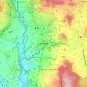
Name: Dorchheim topographic map, elevation, terrain.
Average elevation: 820 ft
Minimum elevation: 512 ft
Maximum elevation: 1,270 ft
Make a donation
Gear up for your next adventure:
As an Amazon Associate, this site earns from qualifying purchases at no extra cost to you.
Other topographic maps
Click on a map to view its topography, its elevation and its terrain.