
Make a donation
Gear up for your next adventure:
As an Amazon Associate, this site earns from qualifying purchases at no extra cost to you.
Montero topographic map
Click on the map to display elevation.
Make a donation
Gear up for your next adventure:
As an Amazon Associate, this site earns from qualifying purchases at no extra cost to you.
Montero
Montero has an elevation of about 300 meters above sea level and an average temperature of 23 °C (73.4 °F). The city is predominantly agricultural, producing soybeans, cotton, corn, and rice.
Make a donation
Gear up for your next adventure:
As an Amazon Associate, this site earns from qualifying purchases at no extra cost to you.
About this map
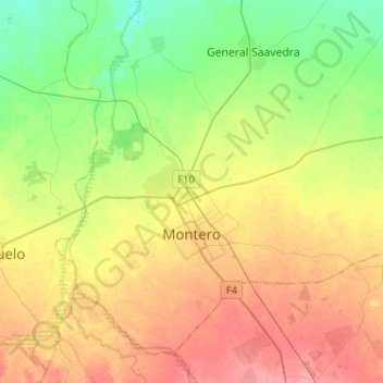
Name: Montero topographic map, elevation, terrain.
Location: Montero, Provincia Obispo Santistevan, Santa Cruz, Bolivia (-17.41899 -63.34717 -17.21069 -63.09104)
Average elevation: 935 ft
Minimum elevation: 833 ft
Maximum elevation: 1,047 ft
Make a donation
Gear up for your next adventure:
As an Amazon Associate, this site earns from qualifying purchases at no extra cost to you.
Other topographic maps
Click on a map to view its topography, its elevation and its terrain.
General Saavedra
Bolivia > Santa Cruz > Provincia Obispo Santistevan > Municipio General Saavedra > General Saavedra
Average elevation: 883 ft