
Mayodan topographic map
Click on the map to display elevation.
About this map
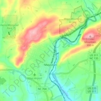
Name: Mayodan topographic map, elevation, terrain.
Location: Mayodan, Rockingham County, North Carolina, United States (36.39604 -79.99923 36.44394 -79.93227)
Average elevation: 712 ft
Minimum elevation: 535 ft
Maximum elevation: 1,004 ft
Rockingham County trails, hiking, mountain biking, running and outdoor activities
Other topographic maps
Click on a map to view its topography, its elevation and its terrain.
Forest Hills
United States > North Carolina > Rockingham County > Reidsville > Forest Hills
Average elevation: 771 ft
Sandy Cross
United States > North Carolina > Rockingham County > Sandy Cross
Average elevation: 810 ft