
Make a donation
Gear up for your next adventure:
As an Amazon Associate, this site earns from qualifying purchases at no extra cost to you.
Lauchhammer topographic map
Click on the map to display elevation.
Make a donation
Gear up for your next adventure:
As an Amazon Associate, this site earns from qualifying purchases at no extra cost to you.
Lauchhammer
Die Stadt liegt in der Niederlausitz, gehörte aber historisch bzw. politisch nie zu ihr. Lauchhammer befindet sich 45 Kilometer nördlich von Dresden. Cottbus ist rund 50 Kilometer entfernt, die Entfernung zur Sängerstadt Finsterwalde beträgt etwa 25 Kilometer. Die Höhenlage reicht von 94 bis 160 m über NHN.
Make a donation
Gear up for your next adventure:
As an Amazon Associate, this site earns from qualifying purchases at no extra cost to you.
About this map
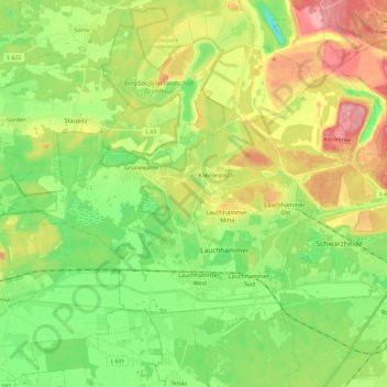
Name: Lauchhammer topographic map, elevation, terrain.
Average elevation: 351 ft
Minimum elevation: 203 ft
Maximum elevation: 561 ft
Make a donation
Gear up for your next adventure:
As an Amazon Associate, this site earns from qualifying purchases at no extra cost to you.