
Make a donation
Gear up for your next adventure:
As an Amazon Associate, this site earns from qualifying purchases at no extra cost to you.
Eutingen topographic map
Click on the map to display elevation.
Make a donation
Gear up for your next adventure:
As an Amazon Associate, this site earns from qualifying purchases at no extra cost to you.
About this map
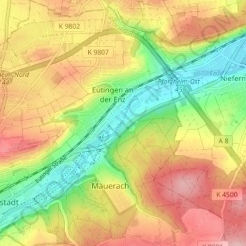
Name: Eutingen topographic map, elevation, terrain.
Location: Eutingen, Pforzheim, Baden-Württemberg, Deutschland (48.88828 8.71929 48.92970 8.76537)
Average elevation: 1,030 ft
Minimum elevation: 764 ft
Maximum elevation: 1,289 ft
Make a donation
Gear up for your next adventure:
As an Amazon Associate, this site earns from qualifying purchases at no extra cost to you.
Other topographic maps
Click on a map to view its topography, its elevation and its terrain.
Pforzheim
Deutschland > Baden-Württemberg > Pforzheim
Sowohl die frühere Stadtgemarkung als auch das heutige Gemeindeterritorium erstrecken sich laut der naturräumlichen Gliederung Deutschlands auf Gäugebiet (Enztal, Kraichgau) und Schwarzwald. Die Innenstadt liegt in einer Weitung des Enztales am Zusammenfluss von Nagold und Enz. Der Gesteinsuntergrund…
Average elevation: 1,234 ft